Avatar

Andrew MacLachlan

Teaching Fellow in Spatial Data Science and Visualisation

University College London

Biography

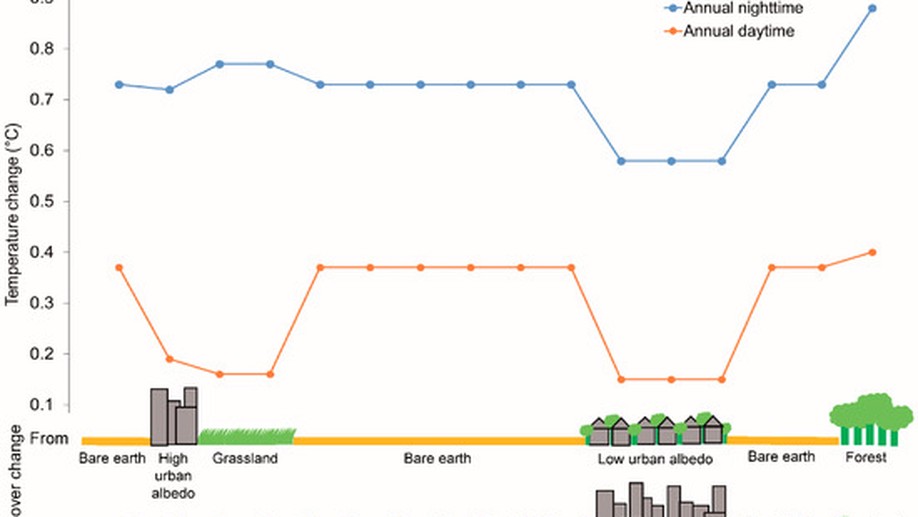
Andrew’s research interests revolve around developing data-driven urban development recommendations to enhance future sustainability and optimise resource investment. This covers the broad themes of: city science, spatial data analysis, dynamic population modelling and earth observation. His doctoral research used Earth observation to quantify urban growth and demonstrated its application to sustainable city development. With a background in remote sensing Andrew has also been involved with field validation of Sentinel-3 data.

Interests

  • Spatial analysis
  • Remote sensing
  • Applied policy research

Education

  • PhD in Geography and Envrionment, 2018

    The University of Southampton and The University of Western Australia

  • MSc in GIS and Remote Sensing, 2014

    The University of Southamtpon

  • BA in Human Geography, 2013

    The University of Sheffield, with study abroad at The University of Wollongong

Recent Posts

Writing technical content in Academic

Academic is designed to give technical content creators a seamless experience. You can focus on the content and Academic handles the …

Display Jupyter Notebooks with Academic

Learn how to blog in Academic using Jupyter notebooks

Academic: the website builder for Hugo

Create a beautifully simple website in under 10 minutes.

Hello R Markdown

R Markdown This is an R Markdown document. Markdown is a simple formatting syntax for authoring HTML, PDF, and MS Word documents. For …

Projects

*

New personal website

Making this new website

Revision of CASA GIS module

Complete update of the CASA GIS module

External Project

An example of linking directly to an external project website using external_link.

Recent & Upcoming Talks

Example Talk

An example talk using Academic’s Markdown slides feature.

Recent Publications

Quickly discover relevant content by filtering publications.

Urbanisation-Induced Land Cover Temperature Dynamics for Sustainable Future Urban Heat Island Mitigation

Through a multi-sensor approach, this research disentangles the complex spatial heterogeneous variations between changes in land cover …

Subpixel land-cover classification for improved urban area estimates using Landsat

This research integrates high spatial resolution orthophotos and Landsat imagery to identify differences across a range of diverse …

Urban Growth Dynamics in Perth, Western Australia, Using Applied Remote Sensing for Sustainable Future Planning

Here, we present multi-temporal urban expansion statistics from 1990 to 2015 for Perth, derived from Landsat imagery.

Contact